MagLogLite is a powerful yet user‑friendly data logging and display controller designed for marine and land‑based magnetometer surveys. It supports single‑sensor and multi‑sensor gradiometer arrays, handling multi‑channel asynchronous data streams with high reliability and excellent data integrity.
The system includes an intuitive step‑by‑step Configuration Wizard, making it easy to set up depth, altitude, and differential GPS inputs with map overlays for real‑time tracking. Operators can configure multiple resizable display windows, each with independent scaling and colour‑coded traces, along with Go/No‑Go indicators that highlight data quality issues instantly.
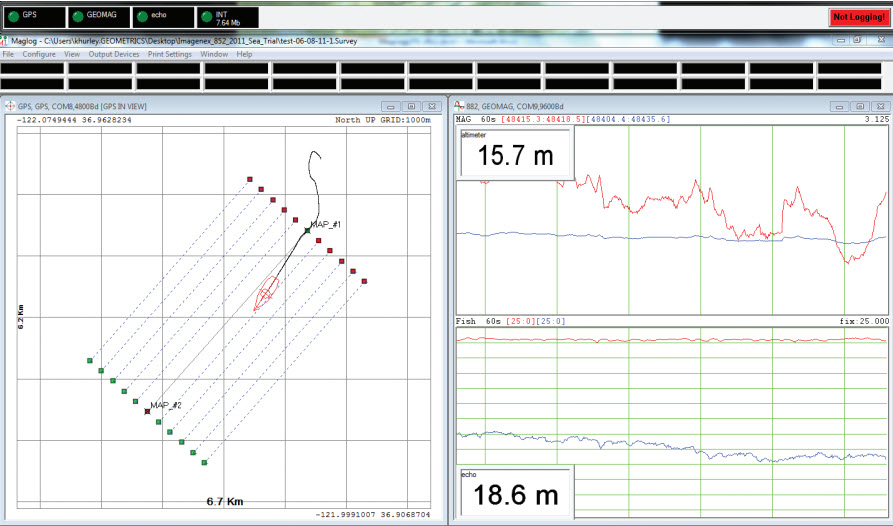
MagLogLite’s multi‑pane interface supports simultaneous display of multiple instruments and includes a 3D highway‑style steering window for navigating predefined survey lines. Cross‑track errors are calculated in real time, and data logging can automatically stop at route endpoints. A dedicated GPS window provides full zoom control and survey‑track plotting, with options to export plots to PDF.
All data is time‑stamped to 10 ms accuracy and logged independently per sensor, ensuring robust performance even when mixing devices with different sampling rates. The software interpolates sensor positions relative to GPS, supports UTM conversion, and exports X,Y,Z or Lat‑Lon‑Magnetometer files for further processing.
MagLogLite can be supplied on a GoSubsea ruggedized high‑performance laptop, or run on customer‑provided hardware.


.svg)
.svg)


